Discussed In This Essay


Four decades ago, a young real estate developer named Robert Davis began work on an 80-acre Florida panhandle site facing the Gulf of Mexico that he’d inherited from his grandfather. Unburdened by debt, Davis could afford to develop the unsightly, logged-and-bushwhacked property gradually rather than covering it with a panoply of houses in one fell swoop. Such were the beginnings of Seaside—an unlikely crucible for the New Urbanism, the most important movement in American urban design since Urban Renewal.
Seaside’s first, Davis-designed houses were simple wooden bungalows raised above open undercrofts with spacious porches, deep eaves, and cross-ventilated rooms resembling those at Grayton Beach, the nearby hamlet where Davis and his planner-architects, spouses Andrés Duany and Elizabeth Plater-Zyberk, were quartered. As graduate students at Yale, Duany and Plater-Zyberk had researched what makes traditional neighborhoods tick. For Seaside, they studied the old towns along the Gulf. From the outset, they focused on situating houses to shape pedestrian-friendly streets—which, in the event, featured a variety of housing types. Thanks to their brilliant success, this little resort community, which will be familiar to some readers as the setting for the 1998 movie The Truman Show, is a landmark in postwar urban design.
In two weighty volumes—Visions of Seaside (2013) and the new Reflections on Seaside (2021)—planner-architect Dhiru Thadani provides a highly informative overview of the planning and evolution of the town and its influence on architecture and urban design. The books are composed of short commentaries and reminiscences by professionals involved with or influenced by Seaside’s creation. Each contains a fine essay by the former dean of Yale’s architecture school, Robert A.M. Stern, putting Seaside in historical context. Each volume also includes an instructive look at the spiritual and ethical lessons to be learned from Seaside by Notre Dame architecture professor Philip Bess. For the general reader, however, the books’ most attractive feature will likely be their copious illustrations.
Tale of Two Cities
Our country has nurtured two very different traditions in shaping our cities, suburbs, exurbs, and landscapes. The more formal, classical tradition builds on an ancient pattern. Roman gridiron towns originated as military camps and developed their complement of temples, basilicas, and other monuments, while “centuriated” landscapes featured multitudes of rectangular farming plots scaled to the needs of yeoman farmers (including military veterans). A magnificent network of roads extended from the Eternal City to the imperial frontier. America’s 1785 Land Ordinance was a lineal descendant of this classical template, as landscape scholar John Brinckerhoff Jackson (1909–1996) observed; it prescribed a vast grid extending across most of the continental United States for the location of new farms and townships.
The classical idea of space emphasized clearly delineated boundaries. In America that meant there was no question as to the limits of the Virginia courthouse square or the New England town green with its meeting house or church. Space was domesticated by means of boundaries. Good fences made good neighbors. Along with the public square, the street served as a key delineator of urban space and of public and private realms. Classical space was also typically geared to permanence, to the creation of enduring civic communities, monuments, and landscapes. It was wedded to a formal architectural tradition that served the same end.
But America also possesses a second, informal, or, as Jackson called it, “vernacular” landscape associated with early European settlement, not least in Virginia. We can’t appreciate the importance of Seaside without taking stock of this tradition. It originated with the clearing in the forest occupied by a crude, mud-chinked log cabin or rudimentary framed house clad with vertical planks and a rough plaster veneer. Neither was erected on a proper foundation. Neither had a room for storage. These were temporary abodes—commodities, as Jackson emphasized in his Discovering the Vernacular Landscape (1984), rather than architectural artifacts. After all, the settler and his family would likely move on after a few years. From the beginning, the vernacular tradition focused not on permanence, but mobility. It can be seen in the simple, generic balloon-frame structures and “box houses” sheltering settlers and, later, transient populations of agricultural laborers, miners, and factory workers. The strip mall was anticipated by the “road ranch” assemblages of dry goods outlets and tradesmen’s outposts in similarly provisional structures along rough, wheel-rutted pioneer trails.
Jackson averred that classical space had had its day. The vernacular tradition had triumphed in the phenomenally rapid postwar proliferation of suburbs and exurbs, spurred by the new heights of mobility afforded by the automobile. In this landscape, housing conceived by the industrial-scale homebuilder as “product” or commodity set the generally uninspiring tone. But classical space continued to define the habitat of powerful elites—places like Beacon Hill, Manhattan, Georgetown, Nob Hill, and older university towns and suburbs. Their coteries of preservationists, conservationists, and environmentalists were contemptuous of postwar exurbia and uninterested in improving it. The word “sprawl” has long epitomized this contempt.
A Walk Around Town
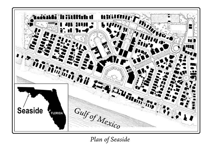
Situated in Florida’s Walton County, between Panama City and Destin, Seaside straddles an east-west shoreline county road, 30A, with the bulk of the site situated north of the road. Duany and Plater-Zyberk laid the community out on a modified grid to accommodate the irregular site. The predominant orientation of the streets is north-south to catch the Gulf breezes. The spacious horseshoe-shaped town center plaza opens southward onto 30A and is focused on a sunken, turfed amphitheater—a locus of community events as well as stormwater retention. The significance of the plan lies in its urban and architectural codes. Instead of laying the community out diagrammatically, employing quantitative criteria aimed at loading as much “product” onto the site as possible, the planners shaped Seaside in qualitative, three-dimensional terms. The urban code prescribed seven architectural types in terms of footprints and building heights, with each type keyed to a specific portion of the town. The architectural code prescribed things like porch depth, roof pitch, window proportions, and materials. Outbuildings—guest cottages—were part of the menu, as were picket fences. The codes nevertheless gave architects (Duany and Plater-Zyberk left the design of buildings to others) considerable leeway.
Seaside streets, originally paved with crushed oyster shells but later with brick, do not run straight. They are canted so that the houses and native trees and shrubs enveloping them can be revealed in slight twists and turns—and to keep drivers from going too fast. As the project attracted more buyers, houses became more luxurious. Double-height wooden porches reminiscent of Charleston, South Carolina, front on Seaside Avenue, which radiates diagonally from the town center. The avenue features a generous, leafy median. On Forest Street, running across the north end of town, the median widens to form a little bosque with trails winding through it.
The town center, unfortunately, is a stylistic pudding without a theme, with three disjointed specimens of modernist architecture fronting on the eastern side of the plaza. The charming jewel-box of a classical post office Davis designed lies near the axis bisecting the plaza—which axis is underwhelmingly framed by low-lying, wooden commercial structures. Despite the passage of four decades, the town center, whose mixed-use buildings feature retail at ground level with offices and apartments above, has yet to be architecturally completed at the horseshoe’s extremities abutting 30A. Across the road are a pleasant open-air shopping plaza enclosed by little temple-like classical cabañas, along with restaurants, villas, and an array of more or less fancifully designed wooden beach pavilions. The pavilions crown the dunes running along the beach; Davis and his architects wisely retained them instead of leveling them for condo or hotel construction, as a conventional developer almost certainly would have done. The dunes serve as windbreaks during hurricane season.
Commercially, the town center is thriving. Davis’s wife, Daryl, is a masterly curator of retail. The center was thronged during my two-day visit in June, especially in the evenings. But Seaside’s most memorable feature is its residential streetscape. The pedestrian paths inserted in the middle of each block are ingeniously distinctive: five feet wide, strewn with white sand, and lined by white picket fences. Conceived by Léon Krier, the most influential designer in Prince Charles’s entourage, these paths serve as convenient shortcuts while dramatically enriching one’s experience of the houses and their low-maintenance botanical cohort of scrub-brush, shrubs, scrub oaks, sycamores, and upland pines. The experience is more intimate—you’re walking between private yards—and more omnidirectional and dimensional, because you’re seeing buildings more fully, more “in the round,” instead of being limited to pictorial vistas. Because the form and scale of the buildings, with their silvery tin roofs and agreeably varied palettes, are mutually reinforcing, a welcoming harmony results. Many of the houses feature picturesque towers, which become higher the further one gets from 30A. They distinguish Seaside from other communities along the road.
A white, wooden church with a steeply pitched roof and openwork belfry terminates the axis leading from the town center. Its design is idiosyncratic but it is readily recognizable as a church. An incomplete civic complex running off the town center on another diagonal includes simple but dignified wooden buildings for Seaside’s charter school as well as an auditorium, each painted white. They have recently been tied together by a colonnade so that they face a lawn, with a wood-planked stage at one end, from two sides. The colonnade supports a raised and balustraded promenade that wraps around the stage. Designed by Thadani, this ensemble was inspired by Thomas Jefferson’s Lawn at the University of Virginia.
Made in America
At the Founding, it was assumed that once frontier terrain had been settled, towns conceived along classical lines—with gridiron layouts facilitating the sale of lots and prominent sites reserved for courthouses and churches—were the natural next step. George Washington, who at 17 had assisted the surveyor who laid out Alexandria, Virginia, subscribed to this dispensation. As president, he commissioned Pierre Charles L’Enfant, an academically trained French designer and Continental Army engineer, to create a classical city plan for the nation’s capital. Sited in a largely uncultivated, topographically irregular landscape, it included a gridiron street network upon which L’Enfant superimposed a baroque array of avenues radiating from the Capitol and “President’s House.” L’Enfant’s 1791 plan is a masterwork.
Modern, large-scale agriculture has pretty much done away with the Jeffersonian ethos underlying the old Land Ordinance, though the grid pattern it implanted on the landscape remains visible when you fly over the American heartland. The classical tradition of community building, for its part, remained vigorous until the Great Depression. It accommodated the innovations in mobility that got underway during the 19th century: the railway, the trolley, and, later, the automobile—all of which encouraged the well-to-do to escape the confines of the noisome city for leafier, more congenial redoubts. In social terms, the proximity of classes to one another in the old core cities was diminished by the advent of inner-ring suburbs like Roland Park in Baltimore, Windsor Farms in Richmond, Virginia, or Shaker Heights outside Cleveland.
During the Depression the mobility-oriented tradition—which never disappeared from the American landscape—redefined the pattern for mainstream American urbanization. The automobile, increasingly within Everyman’s financial reach, was the main catalyst, buttressed by an expanding electrical grid, the telephone, radio, and then television, and eventually the internet. This vernacular landscape didn’t harbor cities and towns where residences, schools, churches, stores, and workplaces co-existed in proximity to one another, but single-use developments, with residential subdivisions often laid out like pods along a stem—the stem being the collector road. The pods themselves often featured lanes terminating in cul-de-sacs with houses fronting on them. The cul-de-sac became the latter-day version of the frontier forest clearing. The extroverted, omnidirectional orientation of the classic American city gave way to a more narrowly linear one, with the traditional neighborhood displaced by introverted enclaves.
The new pattern did not emerge spontaneously. It was formalized—encoded, that is to say—by Uncle Sam. Created in 1934 to reinvigorate the nation’s devastated home-construction industry, the Federal Housing Administration (FHA) issued uniform property insurance standards which builders had to satisfy to qualify for federal mortgage guarantees. It provided large-scale developers with land-planning and other technical standards as well as advance financial commitments. It also created the national secondary mortgage market for the bundling of mortgage-backed securities. The FHA both commoditized and homogenized exurban development. As the Rockford Institute’s Allan C. Carlson has noted, regional architectural traditions were ignored in favor of a few standardized models—“the Cape Cod, the colonial, the split-level, and the ranch”—so that large-scale production housing became about as sensitive to place as the old box houses. The argument the FHA adduced in favor of this homogeneity was that “non-conformity” endangered a property’s value, in which the government now had a vested interest.
The suburbs the FHA, along with the G.I. Bill, helped make possible resulted in a higher standard of living for many millions of Americans. And some large-scale developers like William and Alfred Levitt designed their subdivisions thoughtfully within the parameters federal guidelines afforded, as Witold Rybczynski shows in his superb property-development epic, Last Harvest (2007).
But federal housing largesse was disproportionately channeled to the urban fringe, while supposedly “blighted” but perfectly viable city districts were red-lined—on economic and, often enough, racial grounds. In short order, shopping centers and enclosed malls, houses of worship and megachurches, office parks, government “centers,” community colleges, and hospitals cropped up in their own single-use exurban precincts. Frank Lloyd Wright had seen it coming by the early 1930s, when he wrote The Disappearing City. He envisioned the “decentralization” and “reintegration” of the historic city and advocated the free-standing house on its own acre of land as the American norm. The hub-and-spoke railway network that had served the core cities would be displaced by more flexible truck-based freight delivery serving warehouses on the ever-expanding exurban frontier. “Our pioneer days are not over,” he proclaimed. In another book published shortly before he died, The Living City (1958), Wright observed that the old classical “space values have entirely changed to time values”—the time it took to drive from home to shopping center or school or workplace.
But it’s extremely doubtful Wright would be pleased with our current exurban landscape, which often makes us think in terms of decentralization and disintegration. The rigid disaggregation of urban functions in this new landscape, moreover, was a quintessentially modernist endeavor, never mind the Cape Cods and colonials. And a couple of decades after the FHA issued its guidelines, high-end Corbusian modernism got to work on the nation’s inner cities, with slum clearance doing away with dilapidated but viable, fine-grained old neighborhoods, such as Boston’s Scollay Square and Washington’s Southwest quadrant, to make way for Brutalist superblocks. Housing projects, whether stark towers isolated on forlorn plots of turf or low-rise, barracks-like blocks arranged around interior courts, canceled the traditional street’s clear delineation of public and private space. The Swiss-born Le Corbusier, who suffered grievously from an excessively tidy mind, detested the traditional city’s pedestrian scale and the functional complexity of its streets. The fruits of his malign influence extended to the race riots that plagued the nation during the 1960s.
Small-Town Vistas
Seaside’s financial success was stupendous. The first lots sold in 1982 for $15,000; by 2001 the average lot price was $690,000. For planner-architects Duany and Plater-Zyberk, the main question was how the lessons they learned from Seaside could affect mainstream property development. They focused on the social as well as the aesthetic logic of traditional neighborhood development: on creating streetscapes that reflected local building traditions, and on situating different building types—single-family homes (many with “granny flats” above garages located on alleys), townhouses, and apartment buildings—close to one another to create greater social diversity. They also were concerned with reducing dependence on cars by enabling people to attend to their daily needs on foot.
Their first major mainstream venture was in suburban Gaithersburg, Maryland, on what had been a 356-acre farm, a property four times the size of Seaside. Legally a master-planned development like Seaside, Kentlands looks a lot like a small town. It, too, is laid out on a distorted grid—in this case to accommodate hilly terrain, three small lakes, and wetlands. Streetscapes in its four neighborhoods were inspired by regional locales including Annapolis and Georgetown. But Kentlands proved a much harder slog than Seaside. Construction got underway in 1989, in good time for the biggest housing downturn the Washington, D.C., metropolitan area had seen in over half a century. Though the architectural code was less demanding than Seaside’s, Duany and Plater-Zyberk and the developer could not get the quality they were after. The homebuilders had the whip hand, and it shows.
The developer wound up handing the project over to his bank, but Duany and Plater-Zyberk’s office (now DPZ CoDesign) retained its role as Kentlands’ “town architect.” As the project was built out, the architecture improved. Mature trees now enrich the streetscape considerably. Driving around the place one encounters blocks offering archetypal vistas of small-town America. In our deracinated culture, that is truly subversive. A Main Street with live-work units—retail and offices below, apartments above—was built in the late 1990s. These units, like so much about Kentlands—from the street layout to the alleys and granny flats—violated conventional modernist zoning standards. (Davis had the good fortune to build Seaside on unzoned land.) Around the same time, construction began on a new community adjoining Kentlands. Also designed by DPZ and of almost identical size, Lakelands is closely akin to its neighbor. Leeway was given in the use of synthetic materials such as asphalt tile roof shingles and vinyl siding that are not permitted at Kentlands. Together, Kentlands and Lakelands have a population of about 10,000. One major portion remains incomplete: what is now the Kentlands shopping district. It originated with a shopping center and vast parking lots straddling a boulevard. But early on Duany and Plater-Zyberk managed to have infrastructure laid in that is facilitating the district’s gradual evolution, by way of infill development, into a pedestrian-scale, retail-residential neighborhood. The premium homebuyers pay at Kentlands is probably 15% relative to conventional developments in the same market niche. On the other hand, lots are smaller so property taxes are lower. And residents are apt to spend less time in their cars.
In the 1990s traditional neighborhood development was re-branded “New Urbanism.” A convention was held in Alexandria’s Old Town to organize the Congress for the New Urbanism (CNU) in 1993. Its founding charter urges reversal of the centrifugal dynamic that has dominated the relationship between core cities and exurbs since the Depression. It calls for channeling resources back into cities and towns—and especially inner-city neighborhoods. It decries “environmental deterioration, [and] loss of agricultural lands and wilderness.” (Kentlands is not the only farm site Duany and Plater-Zyberk, both CNU co-founders, have urbanized.) For social and environmental reasons, the CNU is preoccupied with making public transit ubiquitously available. Its take on interstate highways is very different from the Romans’ regard for their imperial road system—which was created to serve legions on the march and dignitaries on official business, not our ever more multitudinous legions of daily commuters. More recently, CNU leaders have demonized sprawl as a prime catalyst of the impending climate apocalypse.
A Little More Whole
It’s hard to believe exurban development is as dangerous as New Urbanists say. At the turn of the millennium, urbanized America took up an estimated 5% of the national landmass, as Rybczynski noted in Last Harvest. Farmland accounted for another 20%, forest 30%, and wilderness nearly half. But for many years now Duany, in particular, has seen the environmental movement as the key medium for getting New Urbanism out of its countercultural niche. Yet the idea that climate change poses an existential threat destined to compel transformation of American urbanization remains extremely dubious. In an essay in Visions of Seaside, Duany speaks of traditional architecture as “camouflage that eases the passage of…some very progressive [CNU charter] agendas.” This notion of style as a covert political tool is wishful thinking. The “agendas” of which Duany speaks—development of more compact urban communities that are the key to achievement of other CNU aims—fly in the face of unrelenting sprawl and declining use of public transit. The word “sprawl” is losing its pejorative connotations, and environmentally-friendly “green sprawl” now has its enthusiasts. If he were with us today, Wright might be one of them.
Even so, New Urbanism is having a salutary impact at different scales and in different socio-economic contexts. In New Orleans, I recently visited a half dozen single and double shotgun houses that a local New Urbanist developer, Neal Morris, renovated a few years back in the shabby but slowly gentrifying Seventh Ward and Tremé neighborhoods north of the French Quarter. Before Morris worked on them, they were wrecks. Renovation took place house by house, resulting in the rehabilitation of 76 rent-subsidized homes. Morris could have made more money more easily by plopping down new apartment blocks in another part of town. Instead, he made the city’s historic streetscape a little more whole.
In the same part of town around the same time, a dilapidated housing project dating to the early 1940s was replaced by a New Urbanist neighborhood, named Faubourg Lafitte, with a variety of traditional New Orleans housing types. The neighborhood was designed not to look like a housing project, and it doesn’t. It was funded with a Department of Housing and Urban Development (HUD) block grant, and its origins lie in the Hope VI program HUD launched during the Clinton Administration, with significant input from the CNU. The idea was to demolish badly designed, crime-infested public housing compounds and replace them with mixed-income, traditionally designed neighborhoods including subsidized housing that doesn’t advertise itself as such. Chicago’s notorious Robert Taylor and Cabrini-Green projects were replaced with neighborhoods under this program. The downside is that most of the demolished projects’ residents have been left out of Hope VI neighborhoods.
The impressively varied range of New Urbanist projects also addresses John Brinckerhoff Jackson’s lament about elite indifference to sprawl. A noteworthy project along these lines is the conversion—by two other CNU co-founders, Elizabeth Moule and Stefanos Polyzoides—of the parking-lot-afflicted main drag in Lancaster, a city in northern Los Angeles County, into a boulevard with a central, tree-lined rambla that can accommodate parked cars or public events. Continuous retail frontages along the boulevard have created a much more inviting atmosphere for shoppers. The project, completed a decade ago, has been economically very successful.
The CNU preaches and practices stylistic agnosticism as regards modernist design. Yet there is an organic kinship between traditional streetscapes and traditional architecture, both of which are calibrated to the scale and proportions of the human body. And Duany and Plater-Zyberk certainly seem to have learned from Seaside’s flawed town center. Eight miles down 30A, the firm’s more recent Rosemary Beach community features a strikingly handsome town center refreshingly devoid of visually discordant modernist buildings. Everything you see is meant to contribute to a whole that is larger than the sum of its parts. Reliance on the inventive interpretation of a range of historic architectural styles has enabled Duany and Plater-Zyberk and other New Urbanist designers to transform 30A into a redneck riviera.
But the “New Urbanism” moniker is a non-starter. It overlaps confusingly with “Urban Renewal,” and “urbanism” has a rarified, academic ring. Even past CNU founding board member and chair Robert Davis says “New Urbanism” reminds him of “New Coke.” Pigs will fly before the New Urbanists re-brand their movement as “Traditional Community Design,” but that would define their finest achievements.
Next in the winter 2022 Issue

What Academic Freedom Is For

Man of Letters